


GIS | March 2023
Drones in GIS: Pioneering Efficiency for India’s Spatial Data
Introduction:
In the rapidly evolving world of technology, Geographic Information Systems (GIS) and Remote Sensing have emerged as powerful tools for data collection and analysis. However, traditional surveying methods often fall short in terms of efficiency, cost-effectiveness, and safety. Enter drones - the game-changer in the field of GIS. This blog delves into the transformative role of drones in GIS, highlighting their advantages over traditional methods. We’ll also explore a case study of Indrones, a pioneer in leveraging drone technology for GIS, and look ahead to the exciting future of drones in this domain.
Understanding GIS and Remote Sensing:
Remote Sensing is the non-contact collection of data about objects or areas, utilizing sensors on satellites, aircraft, drones, and ground instruments. This method involves capturing images of the Earth's surface and analyzing the gathered data. Geographic Information System (GIS) integrates hardware, software, data, and people to manage and analyze spatial data, creating interactive maps. The synergy between Remote Sensing and GIS enhances data analysis and spatial relationships. Applications span satellite imagery, GPS, and other technologies, making this combination integral for diverse fields. The GIS industry in India has experienced substantial growth, witnessing sectors like agriculture, energy, and construction harnessing these technologies for astute decision-making.
How Drones Revolutionize Data Collection:
Drones, initially employed for military surveillance, entered the enterprise domain a decade ago. India's drone sector boasts 200+ startups, showcasing their impact on industries. As India targets a $5 trillion economy, the tech industry, fueled by drones, plays a pivotal role. With the services sector leading GDP, drones contribute to a shift from unskilled to tech-proficient jobs. According to The Times of India, the drone analytics market is projected to hit $6.5 billion by 2027, aligning with India's economic ambitions. Drones have emerged as a disruptive force in GIS mapping in India, providing swift and accurate data acquisition.
Drawbacks of Traditional GIS Methods in India:
Traditional GIS data collection methods, such as satellites and aircraft, often face challenges. The precision of data gathered by drones surpasses that of satellites. While the accuracy of satellite data is typically gauged in meters, drone data can achieve an impressive level of detail, with accuracy measured in centimeters. This stark contrast in resolution can greatly influence the quality and applicability of the data across various fields(See Image for Comparison).
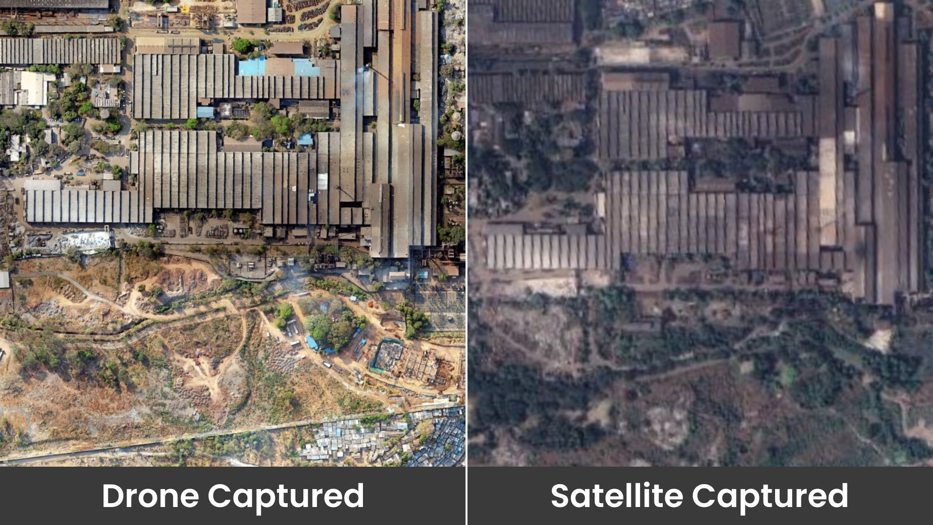
Source : Indrones
Satellites do not provide real-time data, and although aircraft provide it, unlike satellites, the reliability of both can be compromised by obstructions such as cloud cover. Furthermore, companies must rely on third-party agencies for data collection, adding to the complexity and cost. These methods are not only time-consuming but also less sustainable. Ground surveys are often impeded by the diverse and sometimes inaccessible terrains across the country. The need for innovative, efficient, and eco-friendly solutions in GIS data collection has never been more apparent.
Advantages of Drones in GIS:
Speed and Efficiency: Surveys indicate that drones can cover 10 square kilometers in less than an hour, significantly outpacing traditional methods in GIS mapping. According to MDPI, drones can travel up to 100 km/h which can result in 65-74% of time-saving in rural routes.
Cost-Effectiveness: The economic impact of employing drones in GIS mapping is evident. Studies suggest that drones can slash data collection and processing costs by up to 50%, democratizing GIS mapping for various industries in India. According to CompareCamp, drones, in contrast to piloted planes, offer mining firms a potential cost-per-hour saving of up to 90%.
Real-time Feedback: Drones offer real-time data, a critical element in decision-making. Live streaming capabilities, coupled with cloud-based platforms, expedite data processing and analysis.
Safety Enhancements: Construction inherently poses risks, and surveying is not exempt from this. Traditional surveying methods often necessitate workers to navigate challenging areas in dynamic worksites. To truly instill a culture of safety within a construction company, it’s essential to move beyond viewing safety as a mere box to tick to avoid supervisor scrutiny. According to Comparecamp, the use of drones can enhance safety measures at construction sites by up to 55%.

Brief Overview: The Forest Department in Dharwad, Karnataka, sought to overcome the challenges of efficiently surveying and managing a complex forest area spanning 3.2 square kilometers. The primary goal was to conduct an accurate count of Sandalwood Trees within this intricate terrain.
Challenges: Navigating Complexity The forest's intricacies posed a formidable challenge. Conventional surveying methods were time-consuming and limited in covering the vast and complex landscape. The need for an efficient and accurate solution led the Forest Department to explore cutting-edge drone technology.
Solutions: Integrating Technology for Precision: Indrones, a leading drone technology company, deployed a team of seasoned professionals equipped with state-of-the-art technology. The Sigma25 drone, featuring a 24MP RGB camera, was employed alongside specialized software like Agisoft Metashape and the proprietary Eigenspace platform with AI-driven analytics.
Outcomes:
Swift and Comprehensive Data Collection: The Indrones team efficiently covered the entire 3.2 square kilometers in just seven days, with the actual data collection phase taking a mere four days. The Sigma25 drone navigated through the intricate forest, capturing high-resolution imagery essential for accurate tree counting.
Achieving Precision: AI-Driven Analytics: The collected data underwent thorough analysis using Eigenspace's AI-driven analytics. The software not only facilitated the counting of Sandalwood Trees but also provided valuable insights into the overall forest health. The final count submitted by Indrones stood at an impressive 452 trees, with the actual count validating the accuracy at 460 trees—a precision rate exceeding 98%.
Precision Forestry with Indrones: Indrones successfully demonstrated the transformative potential of drone technology in precision forestry for the Forest Department in Dharwad, Karnataka. The seamless integration of advanced drones, high-resolution imaging, and AI-driven analytics expedited the tree-counting process and provided invaluable insights for holistic forest management.
Conclusion:
In summary, drones are revolutionizing GIS mapping in India, providing a faster, cost-effective, and technologically advanced alternative to traditional methods. Their impact on various industries is tangible, with heightened efficiency and substantial cost savings. At Indrones, our commitment is to furnish cutting-edge drone technology to meet the unique GIS mapping needs of diverse industries across India.